Spatial Suitability ANalysis TOol (SSANTO) helps you to find the best locations for the implementation of seven types of Blue Green Systems by exploring the answers to two simple but fundamental questions:
- Where does the urban context best accommodate BGS?
- Where are the various benefits and co-benefits of BGS most needed?
SSANTO helps you explore the answers to these questions by combining diverse sets of “objective” data, including biophysical, socio-economic, planning and environmental aspects, with “subjective” preferences regarding the importance of different objectives of BGS from its users. The tool generates two output suitability maps with intuitive colour coding, one to answer each of the two questions. Together, these maps provide concrete indications of where you can, and where you want to implement BGS solutions. More than merely providing technical guidance for spatial planning of BGS, SSANTO enables the exploration of the full diversity of considerations that should be addressed in the complex planning process. By visualising the consequences of preferences on the importance of different objectives, it fosters exploration, discussion and improved understanding of the planning task.
SSANTO currently has the capacity to evaluate suitability for the following BGS types: raingardens and bioretention systems, infiltration systems, green roofs, rain tanks, swales, ponds & lakes and constructed wetlands. The latest version of SSANTO fully stand-alone, and does not require experience with GIS software. It enables flexible adjustments of objectives, value scales and inclusion of new system types. We keep further developing the tool, which should also become available for spatial suitability analysis in other domains.
What is spatial suitability?
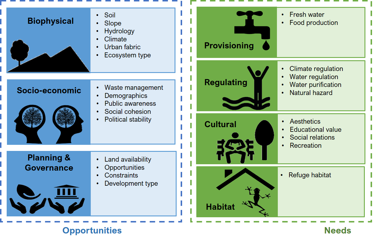
We defined the suitability of a place for the implementation of BGS according to the two fundamental questions above, which refer to the opportunities and the needs for BGS respectively. The answer to each of these two questions depends on a myriad of factors and objectives. To capture these, we developed a suitability framework. We subdivided opportunities for BGS implementation into three categories: biophysical, socio-economic and planning & governance aspects. Each of these categories contain a number of important criteria to include in the selection of a suitable location. The needs side of suitability refers to the ecosystem services provided by BGS. We therefore adopted the categorisation of ecosystem services as used by the UN sponsored Millennium Ecosystem Assessment (MA): provisioning, regulating, cultural and supporting (habitat) services.
While we created the suitability framework in 2017, it is the living basis for SSANTO. This means we keep on improving and updating it, following new insights and application in new and different contexts. More information on the original framework can be found here.
What does the output look like?
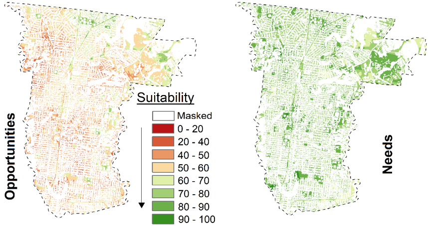
The outputs of SSANTO are colour coded suitability maps. These maps can be simply overlaid on geographic and satellite maps of your case study area, to identify those sweet spots to place your BGS. SSANTO offers you the option to output three different suitability maps, representing the (1) opportunities, (2) needs and (3) a combination of opportunities and needs.
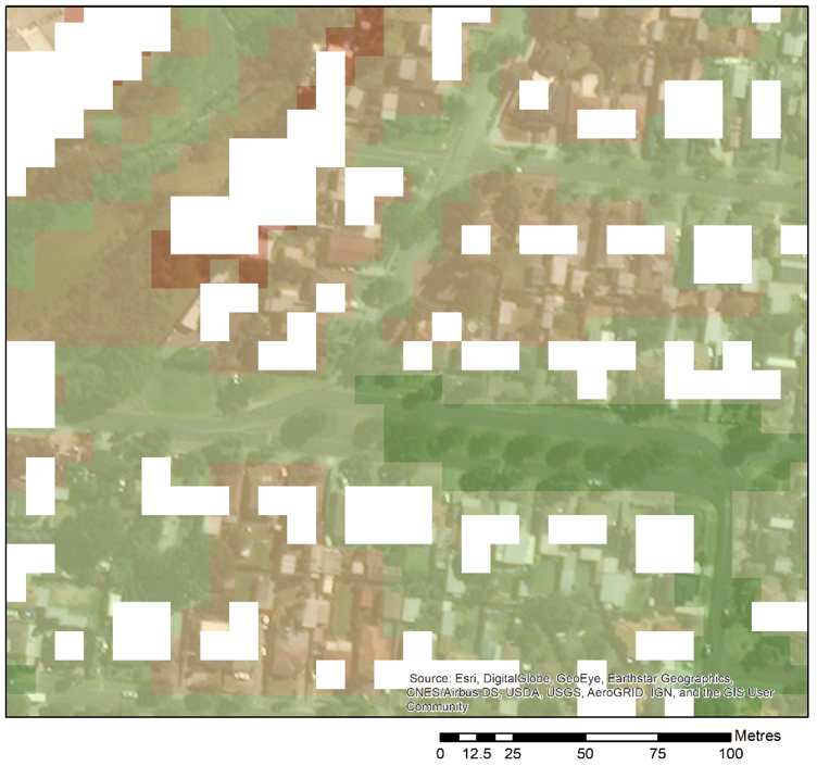
Besides these suitability maps, SSANTO provides some additional information. These includes summary statistics such as the highest and lowest suitability in your case study area, the average suitability, percentage of area above a certain threshold, etc. These statistics are provided in a table, as well as through graphs (histograms of suitability scores). Furthermore, the interactive suitability maps provide further information on the underlying causes of suitability at each location, by clicking on it. This will open a table with a list of all relevant criteria and their individual suitability score at that location, as well as their relative impact on the final result in that location. This enables you to gain further understanding on what makes a location suitable or unsuitable.


Click here to find out more about SSANTO’s functionality and outputs.
How does SSANTO work?
SSANTO is based on a technique called GIS-MCDA, which is a combination of GIS (Geo-Information Systems or Science) and MCDA (Multi-Criteria Decision Analysis). Essentially, it is the process of combining a bunch of spatial datasets by translating each to a common scale (suitability score for the implementation of BGS), followed by assigning subjective relative importance (weight) on each of their contribution to the final output. In summary, the process looks like this:
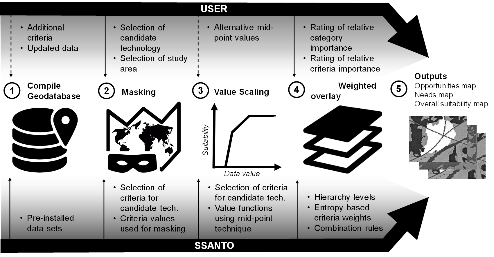
SSANTO standardises and automates much of this process, so you don’t have to think about the details. For example, expert-based value scales (functions that translate raw data into suitability scores for the implementation of a specific system type) are applied. At the same time, SSANTO’s flexible architecture allows you to change the value scales if you so wish to. As a minimum, the user only has to provide their perceived relative importance to the different objectives and criteria. this provokes the user to ask themselves questions such as: “How important is an optimal slope compared to the likelihood of community acceptance of a rain garden?” and “What is more important for the implementation of a wetland, its capacity for water quality improvement, or its role in providing recreational values?”. Besides SSANTO’s current range, you can add new objectives to the evaluation and add extra data to the database. More information on the technical details of SSANTO’s back-end as well as front-end can be found in this paper. For a quick overview of SSANTO and its development background, take look at these slides:


More information on what SSANTO looks like and how to use it is presented in this video tutorial:
Below you can read more about case studies which we have worked on in the past and are currently working on.
Where has SSANTO been applied?
So far, SSANTO has been applied across three continents, in case studies of varying climatic conditions, scopes and sizes. Growing our experience from these cases, we have continued to change and improve the tool, while demonstrating its use. Below you find a brief summary of the case studies for SSANTO. For more information, please check out the case study pages.
| Location | Description |
 Darebin City (Melbourne, Australia) | As the test site for SSANTO, this implementation case was its maiden one. A full set of criteria provided a thorough analysis performed at Monash University, that was compared to the work of a professional exercise performed by the consultancy company E2DesignLab. Results showed that SSANTO can providing outputs in accordance with in-depth professional assessment. For more information, click here. |
 Dandenong IWM Forum Melbourne (Australia) | As part of the Dandenong Integrated Water Management forum, organised by state government and the municipalities of the Melbourne Metropolitan area. The aim is to approach water management strategically by collaboration between local councils to align goals and measures. SSANTO was used on this large case study to explore spatial potential for further implementation of BGS. |
 Georges River Catchment (Sydney, Australia) | First application outside Melbourne, for an area that covers approximately the southern half of Sydney’s metropolitan area. Project performed in collaboration between local NGO Georges Riverkeeper and the University of New South Wales, which included the assessment of the more than 200 currently available assets in the region. Click here for more information. |
 Devon (United Kingdom) | First regional scale application of SSANTO. Initially designed for the analysis in urban areas, this case-study demonstrated SSANTO can also perform larger-scale analysis. Project performed in collaboration with the University of Exeter. Click here for more information. |
 Trois-Rivières (Québec, Canada) | A collaboration between the current affiliation of SSANTO’s developer (EAWAG – Swiss Federal Institute of Aquatic Science and Technology) and two Canadian universities (Polytechnique Montréal and Université de Montréal), and the municipality of Trois-Rivières. This implementation case included a major overhaul of SSANTO’s criteria to suit the Canadian context. Further innovations included newly elicited value scales as well as stakeholder preference elicitation using advances elicitation technique SWING. |
What’s next?
SSANTO is undergoing continuous and major redevelopment. It is now usable independent of proprietary software, while adding some important and useful additional functionality to improve the quality of the outcomes, as well as the user experience. Furthermore, implementation and testing in real world case studies around the world are planned. Some exciting examples of what’s in store:
- Further integration into the UrbanBEATS platform
- Advanced preference elicitation methods, such as SWING
- Easily adjustable and visualised value scales
- Enhanced interactive results, enabling quick impact analysis of different preferences for objectives
- Inclusion of more system types and criteria to cover different climates and contexts
- Enhanced validation and sensitivity analysis
- Further application and testing in diverse case studies around North America, Europe, Australia and the rest of the world
- Application of suitability analysis for different fields besides BGS
Get involved!
We would like to get you involved in SSANTO! No matter whether you are a
- municipality looking to improve its strategic planning for BGS,
- consultancy firm looking for novel approaches to help clients,
- researcher looking to collaborate on topics of BGS and spatial planning and modelling,
- student who is looking for a thesis project
Get in touch with us, and see how you can get involved!
Related publications
- Kuller, M., Farrelly, M., Marthanty, D.R., Deletic, A., Bach, P.M. (2022) “Planning support systems for strategic implementation of nature-based solutions in the global south: Current role and future potential in Indonesia” Cities, 126, 103693. doi: https://doi.org/10.1016/j.cities.2022.103693
- Kuller, M., Reid, D. J., & Prodanovic, V. (2021). “Are we planning blue-green infrastructure opportunistically or strategically? Insights from Sydney, Australia” Blue-Green Systems, 3(1), 267-280. doi: https://doi.org/10.2166/bgs.2021.023
- Webber, J. L., & Kuller, M. (2021). “Enhancing the Visibility of SuDS in Strategic Planning Using Preliminary Regional Opportunity Screening.” ISPRS International Journal of Geo-Information, 10(11), 726. doi: https://doi.org/10.3390/ijgi10110726
- Kuller, M., Bach, P.M., Roberts, S., Browne, D., D., Deletic, A. (2019) “A planning-support tool for spatial suitability assessment of green urban stormwater infrastructure” Science of The Total Environment 686, 856-868 https://doi.org/10.1016/j.scitotenv.2019.06.051
- Kuller, M., Bach, P.M., Ramirez-Lovering, D., Deletic, A. (2017) “Framing Water Sensitive Urban Design as part of the urban form: a critical review of tools and strategies for best planning practice.” Environmental Modelling and Software 96, 265-282, https://doi.org/10.1016/j.envsoft.2017.07.003